ECW Import
This option is on the File/Import Maps menu.
This option is used to import map images in ECW format, these charts have a .ECW file extension.
NOTE : ECW images can also be imported using the Import DRG options on the Import menu. This is useful if the map cannot be imported using the ECW Import option as many essential parameters can be added manually.
It is also possible to use ECW images located on an ECW image server.
Example a file called gtopo30.ecwp would have the first line of the file as
ecwp://www.earthetc.com/images/world/gtopo30.ecwp
ECW images can have geo-referencing included within the image header and if this information is included then the images can be imported and the OziExplorer .map file created. Only ECW images which use a map projection of Lat/Lon or UTM can be imported. Other map projection data will not be decoded correctly and will result in incorrect geo-referencing (calibration) of the map.
The process involves scanning the image files on the CD and creating OziExplorer .map files for each image. The .map files are saved on the hard disk in the path specified. It is these map files which are used to open the charts into OziExplorer.
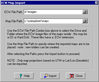
Image File Path - The Path where the ECW image files are located.
Map File Path - The path where you want the OziExplorer .map files to be placed, it is these files you will use to open the map in OziExplorer.
Import - Imports the maps and creates the OziExplorer .map files. The .map files can then be loaded from the map file path using the Load Map from File option on the Load button on the Toolbar. The map image files are not moved and must be available from their original location (usually the CD).