OziExplorer - Features

  Home  |   Ozi Home  |   Features  |   Screen Shots  |   Optional Extras  |   Development  |   GPS FAQ  |   Support  |  


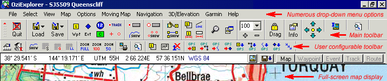
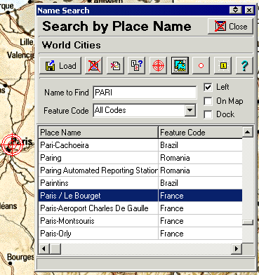
OziExplorer
is GPS Mapping Software which runs on your PC or laptop and will work with Magellan, Garmin, Lowrance, Eagle, Silva/Brunton and MLR GPS receivers for the upload and download of waypoints, routes and tracks, and most makes of GPS receivers for on screen tracking of GPS position (moving map). 


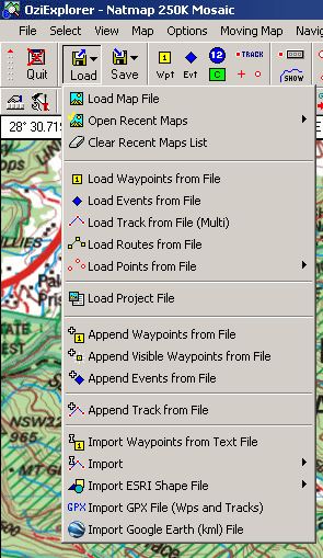
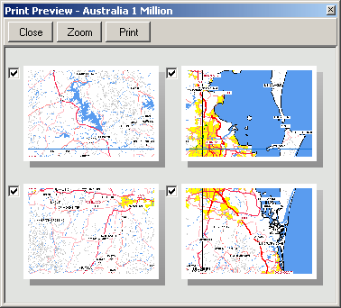
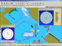
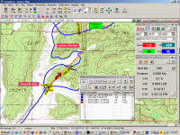
OziExplorer software showing different maps and examples of the many additional data windows.

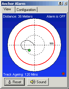
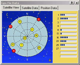
Anchor Alarm and Satellite Display

Waypoint List and Route Editor

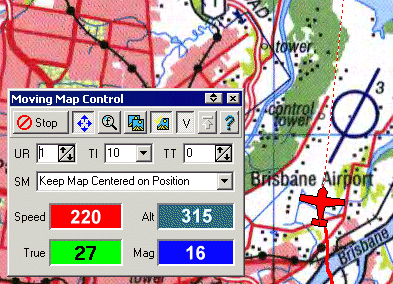
Moving Map and Navigation data

Track Profile

Overview

Plan Your Trip


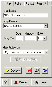
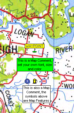
OziExplorer allows you to work, on your computer screen, with maps that you create from purchased digital maps or maps you have scanned.  By using these maps OziExplorer allows you to plan your trip by creating 
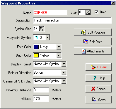
waypoints, routes and tracks on screen and upload these to your GPS. Add special features/symbols and comments to your map.

Also run OziExplorer on your Windows tablet using your maps and data from OziExplorer running on your desktop PC.

Plan on your PC and copy your maps and data to your mobile device / in car navigator running OziExplorerCE (Windows CE O/S) or OziExplorer Android (Android O/S). 


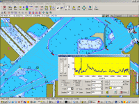
Real Time Tracking (Moving Map)


With OziExplorer running and your laptop connected to your GPS, your GPS position is plotted on the map providing real time tracking ability (moving map). When you leave a map OziExplorer automatically changes to the next map or even better, OziExplorer can search out the most detailed map for the area you are traversing. Use the navigation feature to help you navigate to a waypoint or along a route.


Save Your Trip Data


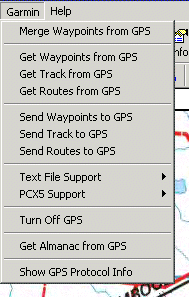
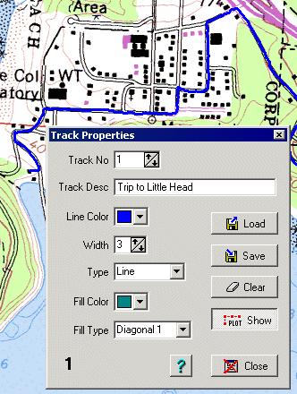
Waypoints, routes and tracks created or collected by your GPS during your travels can be downloaded by OziExplorer and viewed on the map. Using the tools built into OziExplorer these can be edited and saved to your hard disk for future use.  (Save your 4WD track or the waypoints locating your best fishing spots).
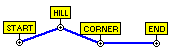
   

Navigation


In moving map mode OziExplorer will navigate you along your chosen route giving instructions when each waypoint is reached. Various parameters such as Speed, Course, Next Waypoint, Distance, CTS, XTE, ETE and ETA are displayed.


Interface to GIS systems

 
  • Useful for collecting data in the field for later use in GIS software.

  • Reads and writes Arcview shape files, reads Mapinfo MIF files, reads E00 files.

Potential Use

 
  • Recreation - boating, 4 wheel driving, flying, hiking/bushwalking, geocaching

  • Rural Fire Fighting

  • Search and Rescue

  • Route planning and guidance for people working in the field


Note : OziExplorer cannot upload maps to any mapping GPS. These require special maps and software which is usually only provided by the GPS manufacturer.


OziExplorer Features List


Load your map to the computer screen and then load from file or download from your GPS to display on your map, other objects such as waypoints, routes and tracks.

Maps and Charts (click for more info)

  • uses Maps in many standard image formats - TIFF, BMP, JPG, PNG

  • uses Maps in many proprietary formats - BSB, BSB 4, BSB 5 and later,NV.Digital, ECW, JP2, MrSID, Maptech Terrain Navigator maps (.024,.100,.250) and Maptech Aeronautical charts (.AER), Kompass.  These formats often have geo-referencing information included in the image or as a separate file which OziExplorer can use to calibrate the map.

  • can use maps you scan yourself

  • map calibration (geo-referencing) ability built in

  • over 100 map Datums supported

  • numerous map projections

  • display the latitude/longitude grid or an alternate grid like UTM

  • attach files to a map to be loaded with the map

  • specify permanent Map features

  • attach a file to each Map feature

  • place symbols and comments on the map

  • load waypoints, tracks, routes, points, events from files to the map

  • measure areas and distances

Map Grid (click for more info)

  • display the latitude/longitude grid or an alternate grid like UTM

  • display labels on the grid borders

  • user can configure grid properties

  • save user default settings


Special calibration dialog to manually calibrate maps if required. Map formats which have geo-referencing information can be auto calibrated using the import option.

Map Calibration (click for more info)

  • 9 point calibration built-in

  • specific calibration methods for each map projection for better accuracy

  • special import for map formats containing geo-reference information

  • zoom window to assist manual calibrations

Attaching Files to a Map to Automatically be Displayed
(click for more info)

  • specify files to automatically load and display information on a map

  • display up to 50 track files on a map

  • display up to 50 point set files on a map

  • display waypoints, events from a saved data file

  • display events and routes from a saved data file


Configure OziExplorer to display a unique menu for your GPS (Garmin, Magellan,  Lowrance/Eagle, Silva/Brunton and MLR).

GPS (click for more info)

  • direct support for most Garmin, Lowrance/Eagle, Magellan, Silva/Brunton and MLR GPS receivers for Uploading and Downloading Waypoints, Routes and Tracks

  • create Waypoints, Routes and Tracks directly on a map for upload to the GPS

  • Waypoints, Routes and Tracks downloaded from a GPS are displayed on the loaded map

  • save Waypoints, Routes and Tracks to files on your computer

  • reload saved Waypoint, Routes and Tracks files to display on any map for the region of the positions

  • numerous options to manipulate your data such as appending files to currently loaded data


Moving Map shows "real time" information as you travel. You can select the icon to display your position on the map.

Moving Map (click for more info)

  • when connected full time to a GPS

    • provides real time tracking ability (moving map)

    • automatically changes to the next map

    • can be set to auto search for a more detailed map

  • ability to log the track onscreen and/or log it direct to a file

  • navigate to a Waypoint

  • or navigate along a predefined Route

  • sound and show alarms when entering Alarm Zones

  • sound and show alarms when approaching waypoints

  • display Range Rings or a Compass Rose at the GPS position

  • choice of pointer graphic or make your own

  • set screen update rate

  • set track tail length displayed (number of track points)

  • set track update interval

  • display speed, altitude and bearing

  • three color mode settings for Night Vision

  • set the screen intensity for night use

  • show your position in a separate Regional Map window

  • anchor alarm

  • satellite view and GPS fix information


The Anchor Alarm will check how far your vessel has drifted from its anchor point and sound an alarm when the value exceeds the specified radius.


The Satellite View will graphically display the satellites your GPS has connected with. The bar graph will show the signal level (SNR) of the satellites in view.


3D/Elevation

 
  • 3D and Elevation options available when OziExplorer3D (separate product) is installed.

  • works with both registered and unregistered OziExplorer and OziExplorer3D. (the unregistered limitations of each apply)

  • most common formats of height/elevation data supported - SRTM, GTopo30, GLOBE, DTED, GridAscii (to use the 3D/Elevation features, height data for the map region is required)

  • has the ability to download SRTM height data for the region of map being viewed

  • view the elevation under the mouse cursor

  • view a map profile along a track or map section

  • create a 3D view of a map (requires OziExplorer3D to view the 3D map)


View what you are printing using the Print Preview option, select specific pages to print.

Printing

  • Print map to any scale, fit to a page or number of pages.

  • Print preview option.

  • Colour or black & white.

  • Waypoint List

  • Event List

  • Route List

  • Print map objects (waypoints, routes and tracks) with or without the background map.


Use Name Search to find and position places from a place names database. A utility is provided to allow you to create your own databases.

Other Features

  • Name Search - search for places by name

    • utility provided to create your own databases

    • advanced search facility

    • create waypoints at a selected place

    • find maps for a selected place

    • filter by feature types

    • filter for located on displayed map

    • add you own waypoints to your database

  • Index Map - displays all available maps

    • load and display a map from the Index Map

    • mouse-over map list feature

    • mouse-over highlight map outlines

    • display a list of available maps at cursor

  • Regional Map

    • use in moving map (tracking) mode to show your position on a map loaded in the regional map window

    • designed to use a map covering a very large area so you can see where you are positioned relative to local landmarks (towns etc)

  • Print Map - print maps to any scale

  • Print Lists - waypoint list, route list


Export and Import

 
  • Export and Import data in many formats

  • Import multiple digital maps (DRG) automatically

    • geotiff images with embedded geo-referencing

    • other images which have a TFW or similar file

  • Export and Import waypoints to/from a text file

  • Export and Import waypoints to/from a GPX file

  • Export and Import waypoints to/from a Google Earth KML file

  • Import Tracks from these file formats

    • Garmin PCX5

    • Waypoint+

    • Mapgen Vector

    • IGC Track Files

    • Compe-GPS Track Files

  • Import MapInfo MIF

  • Import ArcInfo E00

  • Export and Import ESRI Shape files - Points, Polylines and Polygons


Right click on the map, a popup menu will provide quick access to many options

Quick Access to Program Operations

  • Menu access to all features

  • Toolbar - ability to customize the user toolbar

    • main toolbar with dropdown menus

    • user toolbar - select from more than 65 operations, two rows of buttons allowed

    • ability to hide the main and user toolbar

  • Assign operations to Function keys

    • assign up to 11 function keys - select from more than 65 operations

  • Comprehensive Mouse operations

    • map and object drag using the mouse

    • popup menus on maps or map objects

  • Popup Hints when mouse is held over objects such as waypoints

  • Project Manager - allows Projects to be created which consist of map and data files

Types of Map Objects
(Examples are shown)

  • Waypoints 


  • Routes


  • Tracks


  • Points


  • Events


  • Map Features


  • Map Comments


Double click on a waypoint to display and modify the properties of the waypoint

Properties of Map Objects

  • many properties can be configured by the user

  • list of properties which may apply to a particular object

  • font size

  • style

  • name

  • description

  • foreground color

  • background color

  • symbol

  • symbol size

  • position

  • date

Waypoints

  • load up to 100,000 waypoints to your map

  • unlimited number of waypoint files

  • automatic configuration to match your GPS

  • waypoints are used to mark fishing or hunting locations, landmarks, boat ramps, and virtually any other point of interest

  • uploaded/downloaded waypoints to or from a compatible model of GPS

  • user configuration of numerous waypoint properties

  • position waypoints on you map, add them to a route

  • Waypoint List - lists waypoints positions and much more

  • locate waypoints on the map from the list

  • save groups of waypoints to file


Track properties like the color, width and line type can be easily modified

Routes

  • create/load up to 100 routes

  • save routes to file

  • up to 250 waypoints per route

  • unlimited number of route files

  • automatic configuration to match your GPS

  • create a route on the displayed map - attach waypoints to the route

  • uploaded/downloaded routes to or from a compatible model of GPS

Events

  • display up to 1000 events at one time

  • use to mark fishing or hunting locations, landmarks, boat ramps, and virtually any point of interest

  • upload to compatible Lowrance and Eagle models of GPS

  • Event List (for management of events)

  • display a list of positions in Degrees or selected Grid

  • seek and list all maps containing a selected event

Tracks

  • unlimited number of points per track for up to 1000 tracks

  • unlimited number of track files

  • automatic configuration to match your GPS

  • tracks can be downloaded from the GPS

  • manually create tracks and upload to the GPS

  • ability to modify tracks which have been downloaded

  • Track Control (for management of tracks)

  • ability to append a track from a file to the currently loaded track

  • multiple tracks can be displayed on a map at the same time


Points

  • unlimited number of points per set for up to 1000 sets

  • unlimited number of point files

  • many thousands can be displayed on the map at one time

  • each point has a location and a name

  • use to add numerous names and/or locations of objects to a map

  • use for editing the Magellan Datasend POI's

  • use for Importing ESRI Shape files (of type point)

  • Point Control (for management of point sets)


Manually place objects on your map. The position coordinates of any object can be modified in the properties box of the object for exact positioning.

Map Features

  • display up to 500 Map Features / Symbols per map

  • placed on a map, they are used to show the position of places or features of interest

  • select your own symbol to display

  • link to a picture file to a map feature, the picture is displayed with the map feature in the properties dialog

  • Map Feature List - lists map feature positions and much more

  • locate map features on your map from the list

  • scan for maps containing the position of a map feature and display a list

  • save groups of map features to file

Map Comments

  • display up to 500 Map Comments per map

  • placed on a map, these are text objects used to give specific information or notes

  • select your own text properties and background colour including transparent

  • Map Comment List - lists map comments positions and comment text

  • locate map comments on your map from the list

  • scan for maps containing the position of a map comment and display a list

  • save groups of comments in the map file.